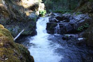
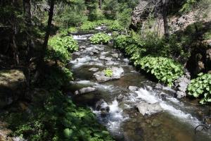
The McCloud River is one of the Mount Shasta region’s premier attractions. The river travels through scenic volcanic features, over spectacular waterfalls and through deep river canyons. Although the McCloud is a popular destination, one of its major physical distinctions often escapes notice. A quick study of the California Geologic Survey’s geologic map reveals that the river travels through two very distinct geologic regions. The upper section, which lies above the McCloud Reservoir, travels through volcanic terrain that includes features like columnar basalt and lava flows. Below the reservoir, the Lower McCloud enters a deep canyon which is cut into mountains that form a nameless outlier of the vast Klamath Mountains. Due to the disruption of the reservoir, the shift in the area’s geologic composition tends to go unappreciated. The change in geology creates two very different river environments. The upper section is identified by past volcanism. The lower section is defined by the exposed bedrock of the Klamath Mountains along the river, the steep walled canyons cloaked in old growth forests and numerous small creeks flowing into the McCloud.
While the upper part of the McCloud along the falls is very popular with hikers, the section of the river below the McCloud is more remote and lacks the major draw of the upper portion’s waterfalls. Consequently, the Lower McCloud River is a treat for hikers looking to immerse themselves in isolation. While the remote location of the trails along the lower part of the river does not make these trails good options for winter hiking because of the snow, in spring access is generally good. Indeed, spring is particularly attractive here. The river is engorged with snowmelt, the trees are leaving and wildflowers are blooming. The distinct geology and the isolation give this area a primeval feeling despite the presence of historic ruins and other man-made structures. The sense of being cut off from the outside world that permeates the Lower McCloud is especially welcome in the spring. After months of snow (theoretically, of course!) and trails near town, this part of the river presents an excellent opportunity to escape into the dark folds of the unnamed mountains south of Mount Shasta.
Three trails are found around the Lower McCloud River. Two follow the river itself and a third follows Squaw Valley Creek, a major tributary of the McCloud that begins at beautiful South Gate Meadow, high on the flanks of Mount Shasta.
Despite not being on the McCloud River, the trail along Squaw Valley Creek has most of the essential qualities that define the trails along the Lower McCloud. It winds through a lonely canyon cut into rugged mountains, has lush riparian landscapes, and has great exposure to one of the region’s beautiful waterways. Squaw Valley Creek is large and swift moving. In the first few miles of the trail it charges through narrow rock gorges and plunges over a pair of small waterfalls. The trail maintains a constant, parallel course to the water and many short side trails provide access to the creek bank. Of the three trails in the Lower McCloud area, the Squaw Valley Creek Trail is the easiest to access. Consequently the trail receives somewhat heavier use than the other two paths. This should not be a deterrent, since the trail still receives light use. Another feature that sets it apart from the other Lower McCloud trails is the fact that it can be hiked as a loop by combining the Squaw Valley Creek Trail, the PCT and a dirt road that travels through a dark, secluded canyon.
Pacific Crest Trail from Ash Camp to Ah-Di-Nah
The Pacific Crest Trail, traveling from the border with Mexico all the way to the Canadian border travels only a few miles along the McCloud River. Due to the rugged nature of the canyon, the river stays high above the water, following a path that is slung across steep slopes. It is the trail’s separation from the river that has likely caused this section of the PCT to largely escape the notice of local hikers. Despite the lack of proximity to the river, hiking this trail has much to recommend it. There is good river access at the trailhead and great views of the McCloud at the beginning of the hike as the trail crosses a large footbridge. After that, even though the river and trail do not come close to each other, there are still plenty of opportunities to observe the water as it races through its boulder choked course. For those intent on enjoying the McCloud up close, there are several side trails that descend down to the riverbank. Some of these offer great views of awesome cataracts. The PCT eventually veers away from the river. Here hikers can continue on a dirt road a short distance to the remote Ah-Di-Na campground, where there is lots of great river access as well as historical ruins of a former fishing camp.
The McCloud River Preserve is located far to the south of Mount Shasta, in the vast, seemingly unexplored mountains that lie between the mountain and Lakehead, where Shasta Lake begins. The preserve began as a private fishing club but was donated to the Nature Conservancy in the 1970’s. The preserve has one trail, which parallels the McCloud River through the heart of a deep, wild canyon. This is one of the most remote trails in the Mount Shasta area. The long, bumpy drive to the trailhead gives a good indication just how far off the beaten place this is. The trail is a fantastic riverside path. With only a few short exceptions, it runs right along the water its entire length, skirting ancient forests and cutting across large sections of exposed bedrock. This part of the McCloud is very different from it more famous upstream section where the falls are located. It is much wider here and dotted with boulders. In contrast to the flat terrain of the falls area, the depth of the McCloud’s canyon is evident along the Preserve Trail. When the route finally peters out, the river continues its journey to south, into the rest of California.
A Spring Backpacking Trip?
One interesting opportunity that this area presents is the possibility of spring backpacking. Starting at Ash Camp, hikers can make the trip down to Ah-Di-Na and set up camp. From there it is another mile walk down the dirt road to the McCloud River Preserve trailhead. The preserve would make a great day hike before returning to camp. It is possible to return to Ash Camp the next day or spend another day at Ah-Di-Na enjoying the river and exploring the ruins. Some years the route of this hike would be free of snow before the long bumpy road into the campground is open. This means that backpackers could enjoy Ah-Di-Na and have the campground to themselves, further adding to the area’s sense of isolation.


